Genealogy Mapping
Mapping Your Czech Genealogy
I feel that discovering your Czech ancestry is an easier task when compared to other ancestries. The Internet seems to be filled with information and resources to support your research. It also seems that even the Czech government and other Czech institutions seem to help with your research.
The same can be said for using maps to supplement your genealogy research.
My family comes from the Kralovice region of the Czech Republic. I am going to use Kralovice homes 138, 177, 185, 187 as examples when a map site is listed below which can help me in my family research. The ** symbol will indicate this. I chose most of the homes I have listed, already knowing they existed in the past and still exist today.
General Internet Sites for Current Czech Maps
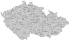
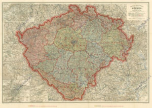
https://en.wikipedia.org/wiki/Regions_of_the_Czech_Republic - Wikipedia has a web page which shows the current Administrative Regions of the Czech Republic and the Districts which are part of each region. The web page also shows the flag and coat of arms of each region. Image Left - Click Here For Larger View
https://en.mapy.cz – A Czech web site displaying maps which appear to be quite similar to Google Maps. ** When I type in Kralovice 185 into the search bar when I reach this web site, it finds Kralovice 185 and also displays an image of the house. The general map, which appears, also lists the home numbers of almost all homes shown on that general map. There are other options for viewing the area. Panorama and 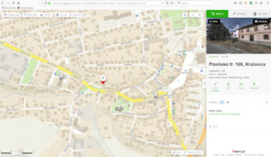 3D, along with a Historical Map feature, which has German spellings for the location. Click Here For Larger View of Mapy CZ Kralovice 185
There is another really nice feature. ** One of the other features this map web site provides is “Information from the Land Register”. Using Google Translate it gives me a bit more information on Kralovice 185, along with the current owner.
https://www.gosur.com/map/czech-republic/ - Another web site for Czech maps, but I have not been able to discover any great value to it yet.
https://www.google.com/maps - Google Maps has several features of interest, though they are close to that offered by https://en.mapy.cz, but require a little more work. When I type in Kralovice 185 into the search bar, it does show me a generalized map of the village of Kralovice. ** I can switch to “Satellite View” and then I can zoom in and view the homes in Kralovice. But unlike https://en.mapy.cz, I have to click on a home for its address to be revealed. Unless I know where my home of interest is located, I have some clicking to do.
Clicking on the home of interest does yield an image of that home (most of the time, as it appears some of the smaller villages do not always have street view options.
Family Search
https://www.familysearch.org/wiki/en/Czech_Republic_Maps - Family Search web page with a focus on describing various Czech maps along with some links to Czech map sites.
Czech Military Maps
I would recommend that you visit Blanka Lednicka’s “Czech Genealogy for Beginners”, as she has a very good summary and links to the three versions of Czech Military Maps
http://czechgenealogy.nase-koreny.cz/2014/04/military-surveys-and-mappings.html
Historical Maps
http://oldmaps.geolab.cz/map_root.pl?lang=en&map_root=mul - Müller's map of Bohemia from 1720 and Müller's map of Moravia from 1716 in print from 1790
https://www.davidrumsey.com/ - The David Rumsey Historical Map Collection has over 11,000 maps online.
https://www.loc.gov/collections/general-maps/about-this-collection/ - Library of Congress Map Collection
https://www.old-maps.co.uk/#/ - British Historic Map Archive
https://mapy.mzk.cz/en/ - Moll’s Map Collection
https://www.oldmapsonline.org/en/Czech_Republic - Just as its name suggests, this site has a good number of Czech historical maps for viewing.
https://cartography-gis.com/docsbca/iccgis2016/ICCGIS2016-75.pdf CZECH HISTORICAL ATLAS – A summary paper (PDF) with a series of good maps as illustrations.
http://www.hiu.cas.cz/en/collection-of-maps.ep/ - Institute of History of the Czech Academy of Sciences – “For users of the collection, there is an electronic, on-line accessible catalogue available, which is part of the catalogue of the Library of the Institute of History, and includes maps and plans. It is currently possible to search in them and browse in a preview cartographic documents from the period from the 17th to the first half of the 20th century, including Section III Military Mapping.” NOTE: Additional historical map links here.
http://www.chartae-antiquae.cz/en/ - “Virtual Map Library was created as one of the results of project Cartographic Sources as Cultural Heritage. The goal of the project, financed by Ministry of Culture, is to devise and refine new methods for digitalization and online publication of cartographic works. Digital maps of selected regions will be used for the reconstruction of historic landscape and settlements.
 To achieve this goal we needed digital representations of old maps, atlases and globes. On that account we approached archives, museums, libraries etc. with an offer to digitize their map collections as part of the project. The participants range from nation-wide to regional institutions and from their maps is shaping up a unique digital map collection, accessible on our web portal. In 2015, when the project ends, we expect this digital library to contain around 40 000 maps, plan, atlases and globes.”
Map Citation:
Hölzel´s Hand-Karte des Königreiches Böhmen. In: Virtualní mapová sbírka Chartae-Antiquae.cz [online]. Zdiby: Výzkumný ústav geodetický, topografický a kartografický, v.v.i. [cit. 2019-09-09]. Dostupné z: http://chartae-antiquae.cz/en/maps/11064
Cadastral Maps
Cadastral maps are genealogy gems. They are maps of villages and farm lands. They have the names of those who worked those fields at the time the maps were drawn. They show homes and house numbers present at the time of the map being drawn.
https://archivnimapy.cuzk.cz/uazk/pohledy/archiv.html - This is the Czech web site I use for Cadastral Maps.
**I use this Cadastral Map site to locate and/or verify that the home I am viewing on a current map is still the location of a home I am working with. On the Kralovice Cadastral, I was able to verify that Kralovice 185 was still in its proper location and that Kralovice 177 was no longer at its location as show in the Cadastral Map of 1839.
http://czechgenealogy.nase-koreny.cz/2014/07/stabile-cadaster-maps.html Blanka Lednicka web page with perhaps the best explanation of how to access and use the cadastral maps
https://knihovnarevue.nkp.cz/kplus-text-en/archives/2017-1/reviewed-articles/online-availability-of-selected-czech-digitized-map-collections-in-the-czech-republic - This is a second Czech website with a listing of other map collections and a description of the Cadastral Maps and how to access them.
https://www.familysearch.org/wiki/en/Czech_Republic_Land_and_Property#Cadastral_Surveys – Looking for additional information on Czech lands, property, estate holdings? – This Family Search web site is a good place to start.

Czech Diocese Maps
https://www.familysearch.org/wiki/en/Czech_Republic_Parish_Finder - If I discover the name of a village of someone I am researching, I turn to the Family Search Parish Finder web page to find the area that village is found within.
http://www.czechfamilytree.com/regarchives.htm - I then use the Czech Family Tree Regional Archive web page to reach the Czech Archive I hope that village is located within.
Sometimes I have no luck, but hope that I am close to the village I need, so I try to search a nearby parish in the hopes of finding records for my person of interest.
http://czechgenealogy.nase-koreny.cz/2015/01/maps-of-czech-catholic-parishes.html - Blanka Lednicka really helps with this, as she has a series of Catholic Czech Diocese Maps at her website. She even has them set up for a zip file download.
Plat Maps - USA Version of Cadastral Maps?
If you seek a cadastral map to find an ancestor's name on a plot of land in Bohemia, a plat map of land in a USA state can do the same. But, plat maps are not in one location, or available without charge, or found for each state. However, there are some plat maps available online.
Ancestry has perhaps the single largest collection under the title - "U.S., Indexed County Land Ownership Maps, 1860-1918."
Family Search lists a number of County Land Ownership Maps, and many are listed as available through some Family History Centers and Affiliate Libraries.
Searching the Internet, a slow process, can still yield results. The University of Wisconsin has a link to an online 1873 plat map book of Dane County, Wisconsin.
The plat might shown right (Click Here For Larger Image), I found with the help of a historical society. It shows family and soon to be family, farms owned in 1896 in a township in Vernon County, Wisconsin.
Not A Map - But - Land document for first sale of Federal Land
Federal Land Patents offer researchers a source of information on the initial transfer of land titles from the Federal government to individuals.
If someone of interest may have purchased land directly from the federal government, you could find it in this Bureau of Land Management database.
Right - Image of purchase in Webster County, Iowa by Margaret Field. Click Here for a larger view.
Census Tracts - Chicago
Every once in a while I can not find a person who should be easily found. I know their address, but a usual search, as I do in Ancestry, or Family Search, does not yield a result. I gamble that the name in the database record is so different than what I would expect, it does not reveal itself in "Wildcard" or other types of searches. So I try to use census tracts.
If I do not know which census tract to look in Cook county, I start with my known address and a web site, https://alookatcook.info/.
I choose my census year and a ward map of Chicago appears. Image left.
I click on the ward which appears to hold the known address. A map showing the Enumeration Districts for that census and their street boundaries appears. Click Here Sample 1880 Chicago Ward 8.
I can then return to ancestry.com and choose the census year, state, county, city, ward and census tract. It appears and now I search for the address and my person of interest. Sometimes I am amazed at how badly they copied the name into the database. Once in a while I still do not find the person I am looking for.
I also use this web site as they have a listing of Chicago street name changes. For years I could not find Robey on a Chicago map. I eventually learned it became Damen.
Maps - Chicago Area
Archdiocese of Chicago Map - Map of Chicago Parishes (PDF) Maps of Chicago - Chicago Interactive Maps